
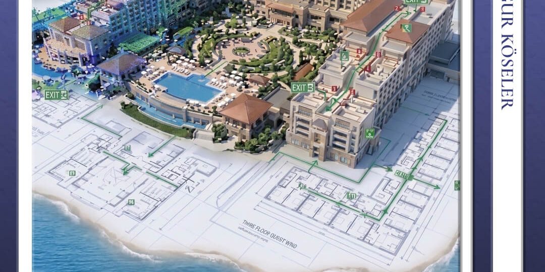

Fire safety, fire prevention systems, and emergency evacuation infrastructure constitute the most critical components of guest and personnel safety in tourism facilities. Particularly in hotels, holiday villages, and large-scale, complex tourism complexes with extensive campuses, significant discrepancies arise between the original architectural drawings and the actual as-built conditions due to renovations, interior modifications, and spatial expansions undertaken since the initial construction of the buildings.
This situation creates significant life-safety risks during fire safety license renewal procedures, official inspections conducted by public authorities, and actual emergency situations. By employing high-precision Terrestrial Laser Scanning (Terrestrial LiDAR) technology, Körfez Harita generates highly accurate three-dimensional models of the interior and exterior spaces of tourism facilities, providing an accurate and comprehensive technical basis for regulatory-compliant fire safety projects.
Legal Regulations and Regulatory Compliance
The laser scanning survey data and 3D models produced are fully aligned with the principal legal regulations with which tourism facilities are required to comply:
– Regulation on the Protection of Buildings Against Fire: Escape route distances, fire compartment boundaries, emergency exit door widths, fire escape stairway inclinations, and the actual dimensions of smoke extraction shafts within the existing architectural structure are measured with high precision. Whether the maximum permissible escape distances specified in the regulation have been exceeded is simulated using the 3D model.
– Occupational Health and Safety Law No. 6331 and the Regulation on Emergency Situations: Actual geometric data forming the basis of the facility’s emergency evacuation plans are obtained. Narrowings and architectural obstructions along evacuation corridors are identified, and corresponding risk maps are generated.
– Regulation on the Qualifications of Tourism Facilities of the Ministry of Culture and Tourism: An up-to-date digital dataset is prepared for architectural compliance assessments and fire prevention certification procedures required during inspections for tourism investment and operating certificates.
Technical Workflow: From Laser Scanning to Fire Safety Integration
1. Field Scanning (LiDAR) → 2. Point Cloud Processing → 3. As-Built CAD/BIM → 4. Regulatory Compliance and Integration → 5. Reporting
1. Generation of a High-Density Point Cloud: All architectural details of the facility, including corridor widths, stairwells, service installations above suspended ceilings, floor-to-floor heights, and emergency exit doors, are scanned using Terrestrial Laser Scanners (TLS). A high-resolution point cloud dataset comprising billions of digital measurement points is generated.
2. As-Built Survey and Architectural Accuracy (CAD & BIM): Particularly in older buildings or hotels whose original architectural drawings have been lost over time, existing digital data deficiencies are addressed by transferring the actual site conditions directly into a 2D CAD/BIM environment with high precision. Structural elements and major MEP (Mechanical, Electrical, and Plumbing) components are modelled.
3. Fire Escape Routes and Evacuation Analysis: Based on the standards stipulated in the Regulation on the Protection of Buildings Against Fire, escape distance analyses, fire escape stairway capacity calculations, and clash detection assessments involving emergency exit signage and directional systems are performed using the generated 3D models.
4. Fire Protection System Integration and Modelling of Active Systems: The actual locations of fire detection and alarm call points, sprinkler (water-suppression) lines, smoke dampers, fire hose cabinets, hydrants, and emergency lighting fixtures are incorporated into the architectural base model. Potential clashes between existing fire protection installations and the architectural structure are identified, thereby preventing design errors.
5. Institutional Approval and Official Reporting: Detailed floor plans, sections, and 3D fire safety models are delivered in accordance with the approval procedures of hotel management, occupational health and safety (OHS) specialists, fire safety consultants, and the Fire Department.
Obtain a quotation today for regulatory-compliant fire safety as-built surveys and terrestrial laser scanning solutions for your tourism facility. Our expert engineering team is ready to assist you. Click here to contact us.
Frequently Asked Questions (FAQ)
What advantages does terrestrial laser scanning offer over conventional methods for conducting fire safety as-built surveys in tourism facilities?
Measurements performed using conventional tape measures or laser distance meters may result in overlooked details, inaccurate escape distance calculations, and undetected architectural obstructions, particularly in complex hotel buildings and facilities covering extensive areas. In contrast, Terrestrial LiDAR scanning digitally captures the entire space as an integrated whole with zero measurement error, eliminating measurement-related complications and the need for repeated site visits.
Is the use of BIM (Building Information Modelling) mandatory for fire safety as-built surveys?
Although BIM is not legally mandatory for all buildings, BIM-level modelling (LOD 200–300) provides significant advantages in complex tourism facilities by enabling the identification of clashes between architectural structures and mechanical fire protection installations (e.g., sprinkler systems and smoke extraction systems). This approach substantially facilitates the processes conducted by fire safety consultants and the relevant fire department for project approval.
Which technologies does Körfez Harita integrate into fire safety surveys conducted in hotels?
Körfez Harita employs an integrated approach combining high-precision Terrestrial LiDAR scanning equipment, mobile mapping solutions for extensive areas, UAV (Drone)-supported photogrammetry for roofs and exterior facades, video documentation, and integrated 3D mesh modelling techniques to generate comprehensive datasets.
Does Körfez Harita have experience in fire safety projects for hotels?
In addition to its experience in numerous as-built survey projects, Körfez Harita has specifically implemented this application at Liberty Lykia Hotel. Further details of the project can be accessed here.
Uğur Köseler
Uğur Köseler graduated from the Department of Geomatics Engineering at Selçuk University in 2011. He currently continues his professional career at Körfez Engineering Surveying Co. as the Director of the Photogrammetry Department. Since 2013, he has contributed to more than 250 projects within the company as both an engineer and a project manager in the fields of photogrammetry, flight planning, LiDAR and GIS (Geographic Information Systems).